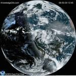
On March 3, a major winter storm brought snow to the mid-Atlantic, freezing rain to the Carolinas and rain and some freezing rain to the Gulf Coast states. The cloud data from NOAA’s GOES-East satellite were overlaid on a true-color image of land and ocean created by data from MODIS, an instrument that flies aboard NASA’s Aqua and Terra satellites.
Related: Iceberg B-31, as big as city, breaks free